
Best Philippines Road Trips: Circumnavigation of North Luzon
Everyone loves a road trip, or so the saying goes, and in the Philippines there’s one big road trip that every keen traveller dreams of doing — and that is a complete circumnavigation of the main island of Luzon.
The shape and topography of Luzon means that it is not possible to do a circumnavigation of this 100,000 sq km island without passing through Metro Manila twice, so most who tackle this trip will do it in two road trips from the capital — one of northern Luzon and one of southern Luzon.
Each trip takes about seven days on the road, with 10 days being the minimum duration if you want to stop and spend some time at the main sights along the way. It is recommended that older travellers with more time on their hands should plan to be away for two weeks for each trip to get the most enjoyment out of the experience.
This article describes the route of the northern Luzon road trip. Although the trip can be done in a clockwise or anti-clockwise direction, it’s recommended that you take the anti-clockwise option so that you keep the ocean on your right at all times, making it easier to pull off the road at lookouts and other viewpoints.
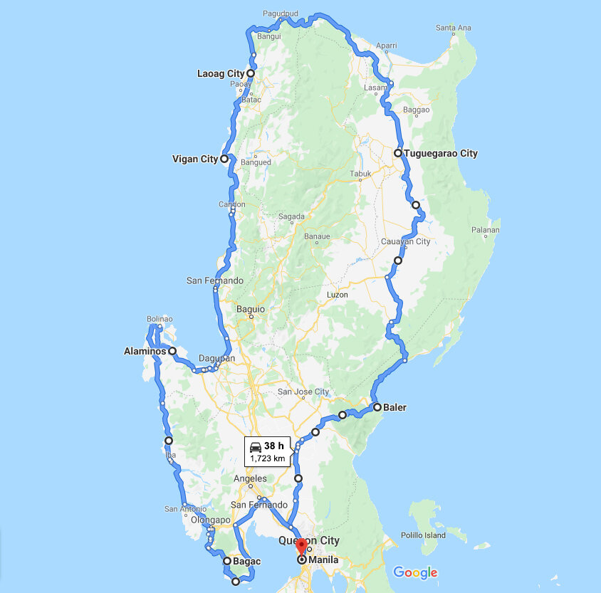
According to Google Maps, the circumnavigation of northern Luzon involves 38 hours driving, but that’s “without traffic”. Of course, as everyone knows, there are few places in the Philippines that don’t have traffic (but you will get to experience some of them on this drive). The actual driving time will likely be between 40 and 45 hours depending on which part of Metro Manila you will be starting from and finishing at.
Driving day 1 – Manila to Baler (7-8 hours)
The first leg of the road trip to Baler in Aurora province will be the longest driving day, so it’s wise to make an early start from Manila to ensure that you get over the Sierra Madre mountain ranges near Baler before dark. Sunday is the best day to leave Manila as traffic is lightest on Sunday mornings. Driving time will be 7-8 hours depending on traffic conditions and from what part of the metropolis you are starting the journey.
You will head out of Manila on the North Luzon Expressway (NLEX). Strictly speaking, to do the most complete circumnavigation of northern Luzon you should leave on the Quirino Highway and head towards San Jose del Monte City, but that road is slow and heavily congested and will add at least two hours to the trip.
Better to take the NLEX to Balagtas and then take the Plaridel Bypass exit. You will join the road from San Jose del Monte City near the Angat reservoir – the main source of Manila’s water supply.
It’s a good idea to pick up something for lunch at the Shell rest stop on the NLEX just before the Plaridel exit because you won’t have many other options for lunch until you get to Cabanatuan City, which is over halfway to Baler.
There are two exits almost immediately after the Shell rest stop. The first one is Exit 32 and is sign posted to Tabang. Make sure you don’t take that one because that road heads west in the wrong direction. Take the next one, Exit 34, which is signposted to Balagtas. That takes you straight onto the Plaridel Bypass.
About 4 km from the NLEX Balagtas toll booth you will see a sign to Cabanatuan City pointing to the left. Ignore that sign and go straight on. That sign was erected during the days the Plaridel Bypass was being constructed and has yet to be removed.
From the NLEX through to Cabanatuan City, it’s mostly a two-lane highway (widening to four lanes in places) carrying fairly heavy traffic, and you won’t see much except rice fields and light industry. It’s not until after Cabanatuan City that the scenery starts to get interesting and the Sierra Madre ranges appear in the distance.
From Cabanatuan City there are two routes to Baler. One is the old Nueva Ecija – Aurora Road through Bongabon, and the other is the slightly longer but newer (and faster) Pantabangan – Baler Road a little further to the north.
If you are using a navigation app, it will surely direct you via the Pantabangan – Baler Road because that’s usually about 15-20 minutes quicker, but to do a true circumnavigation you should take the Nueva Ecija – Aurora Road instead. It takes a little longer but it’s a much more scenic drive than the newer road.
As most traffic now uses the new road, you’ll find driving on the Nueva Ecija – Aurora Road a real pleasure because it carries very little traffic. However, it climbs to a much higher elevation crossing over the Sierra Madre ranges, and it does suffer more landslides, so if it’s raining it may be safer to use the Pantabangan – Baler Road instead.
If you do take that route, then there is a very good option for a late lunch at a resort called Highland Bali on the Pantabangan Lake, about 40 minutes after you leave Cabanatuan City. It’s clearly signed and not far off the main road. You will pay an entrance fee of 350 pesos per person to enter the resort, but that can be used towards the purchase of food and drinks. They have an excellent restaurant offering undoubtedly the best food anywhere on the route between Manila and Baler.
During the rainy season the Nueva Ecija – Aurora Road may have restricted opening hours if road repairs are being carried out. If this happens a notice will be posted at the intersection with the Bongabon – Rizal Road about a kilometre after the Bongabon High School. There is a small S.C.A. gasoline station right on the corner.
Should you arrive and find the road is closed, you can simply carry on along the Bongabon – Rizal Road and join the Pantabangan – Baler Road about 6-7 km further on. That won’t add more than 10 minutes to the journey.
If you are taking the Nueva Ecija – Aurora Road, ensure that you are there at least an hour before dark. As you cross the mountains, there are several places on the left hand side of the road where you can pull off to admire the views. There are a couple of short sections that are still unsealed, but they are passable by all types of vehicles. You may also come across a military checkpoint, but don’t worry, the soldiers are friendly and will most likely just wave you through with a smile.
As you cross into Aurora province and descend into the river valley on the other side of the mountains, you’ll feel like you are entering another world. Aurora is one of the least densely populated provinces in the Philippines with rainforests, waterfalls and beautiful beaches. It’s very much a back-to-nature experience.
Baler
The capital of Aurora province, Baler (pronounced Ba-lair, with the emphasis on the second syllable), is not a large town. Only 40,000 people live there, so it’s easy to get around. It’s located right on the coast and is well known amongst Filipinos as the birthplace of surfing in the country.
The surf is not big — except on some days in the rainy season when storms may produce a big swell — but it’s fairly consistent throughout the year. So if you’ve done some surfing in your younger days and would like to try your hand again, this is a good location to do it.
Baler is credited with having introduced surfing to the Philippines. It is where the horrifying aerial napalm attack of the 1970s Vietnam war film ‘Apocalypse Now’ was filmed, and for recreation the film crew used to surf. Filipinos observed them doing this, and when filming was finished and the crew left some surfboards behind, the locals taught themselves how to surf from having watched members of the film crew do it.
The main beach — Sabang Beach — is a grey sand beach and not particularly photogenic, but there are many more picturesque white sand beaches in coves to the north and south of the town. You’ll need to book two nights here to give you time to explore the town, the beaches around it and visit Baler’s main non-surfing attraction — the Ditumabo Mother Falls.
The Ditumabo Falls is the most spectacular of the many waterfalls in Aurora province. It is actually in San Luis, a municipality adjacent to Baler, which you will pass through on your way into Baler. But you won’t have time to visit them on the day you arrive because you’ll need about two hours to do the trek to the falls and back.
The turn-off to the Ditumabo Falls on the Nueva Ecija – Aurora Road is about 30 minutes back from Sabang Beach. There is a parking area about 2 km off the main road, and from there it is a 40-45 minutes hike to the waterfall. It’s a fairly easy hike that’s not particularly steep, so should be able to be tackled by most able-bodied older travellers.
However, it’s not suitable for anyone who may require assistance in walking because it is necessary to cross a swift-flowing river 3-4 times in water that is between ankle and knee high in depth. The riverbed is rocky, so it’s important to wear footwear that will prevent you slipping on the rocks.
There is an entrance fee of 30 pesos per person and it is compulsory to take a guide for which there is an additional fee of 200 pesos per group. Whilst it would not be difficult to find the waterfall without a guide (just follow the river upstream) the guide will show you the easiest places to cross the river and help you to negotiate some of the slippery boulders.
It’s a very enjoyable hike through rainforest and around small rapids, and you’ll surely be impressed by the waterfall when you first sight it. Pouring off a rocky cliff in the rainforest, it is 140 ft high and there is a pool underneath in which you can swim if you’d like to cool off for a while — but the water is very cold.
Our guide told us that the Ditumabo Falls attract quite a crowd at weekends, but during weekdays it is not uncommon to be the only persons at the waterfall, although you’ll undoubtedly pass a few other visitors on the hike there or on the way back. The guide will expect a tip on top of the guide fee.
Other things worth doing on your day in Baler include a drive down to Disquisit Beach (on the way you will see the craggy Dimadimalangat Rock Formation just off shore), a walk across the Baler Hanging Bridge over a river just south of Sabang Beach, and a visit to the Museo de Baler to learn a little about the history of Aurora province. The museum is not very well organised, but the entrance fee is only 30 pesos and it’s worth browsing for 10-15 minutes. There is a small exhibition of contemporary art upstairs.
Accommodation and eating options are quite good in Baler. The most upmarket option is the 4-star Costa Pacifica resort on Sabang Beach, but it does attract a lot of families, so can be quite noisy with all the children around the pool. There are plenty of quieter and cheaper options away from the main town. We stayed at the Kahanamoku Bed and Breakfast just past the Baler Fishport, which is good value for money.
There are quite a few good restaurants around the main town. The Beach House at the Costa Pacifica is very good, and the Kubli Bistro is a good choice if you’re looking for something a little cheaper. Charlie Does, across the road from the Costa Pacifica, serves light vegan meals and the best coffee in town.
Driving day 2 – Baler to Tuguegarao (6 – 7 hours)
The morning of the second day of driving provides one of the highlights of the road trip, but the afternoon drive is very uninspiring. The road north from Baler is one of the most scenic coastal drives in the Philippines, and it carries very little traffic.
After about an hour and a half on or close to the coast, with the road passing both grey pebble and white sand beaches, and climbing up over rocky headlands covered in thousands of tall coconut palms, you’ll take a left turn about a kilometre after Dinadiawan Beach. That road has the long-winded name of the Cordon-Diffun-Maddele-Aurora Road and provides a very scenic drive back over the Sierra Madre ranges that is as good as the Nueva Ecija – Aurora Road on which you would have travelled on the first day. The road is in very good condition and is less prone to landslides than those further south.
As the highway descends from the mountains down into the Cagayan Valley, there’s one place where you can easily get lost if you are not using a navigation app. As the highway passes through the village of Disimungal it does a sharp left hand turn. But the road also goes straight on, and it is not clear which road is the main highway.
There is a sign just prior to the junction that reads ‘To San Pedro’ (straight on) and ‘To Abbag’ (left) but that will only confuse out-of-town travellers because neither San Pedro nor Abbag (which are both small villages) are shown on most maps. You must take the left turn there otherwise you will end up at a dead end on the wrong side of the Cagayan River and no way to cross it.
The first city that you will reach in the Cagayan Valley is Santiago. It is home to the valley’s only large shopping mall — Robinson’s Place — that you will see on the right as you leave Santiago City. It is advisable to stop there for lunch, because there are few eating-places after that, and also pick up food for the following day because Day 3 offers even less eating options until you reach your destination on that day.
The afternoon will be very unexciting after the scenic morning drive because between Santiago and Tuguegarao there’s nothing but rice fields, small towns, trucking yards and some light agriculture-based industries. You will need to watch out for slow-moving tricycles, tractors, farm vehicles and buffalo carts.
There are two routes between Santiago and Tuguegarao. The one that you should take to do a true circumnavigation is the easterly one via Ilagan and San Pablo, but if you want to ‘cheat’ a little and save about 20 minutes on the journey you can take the newer and faster westerly route though the towns of Roxas and Quezon.
Tuguegarao City is the one overnight stop on this trip where the accommodation and eating options are not good. The options are much better in Santiago City, but that would make the Day 3 travelling time too long. There are no other towns or cities in the Cagayan Valley where better accommodation is available.
There are however a few reasonably good looking apartments in and around Tuguegarao City on Airbnb. We’ve not tried any of them, but they could be a good alternative if none of the options on the hotel booking sites appeal to you.
Driving day 3 – Tuguegarao to Laoag (6 – 7 hours)
Unless you’re in a hotel that might serve a very basic Filipino breakfast, you’ll need to rely on what you bought in Santiago City the previous day for breakfast and lunch today. There are only few fast food places in Tuguegarao City and then very few eating options until you get to Laoag City — aside from roadside food stalls selling local canteen type food.
The morning drive on the third driving day will be much the same as you saw on the afternoon of the previous day as the road follows the Cayagayan River north, and then crosses over the river on a large suspension bridge at Magapit.
It is here that a road heads off to the east to Santa Ana on the northeastern tip of Luzon. Some road trippers like to include that on their itinerary because it makes the trip more of a circumnavigation, but it involves doubling back along the same road to the Magapit suspension bridge, and there is not much to see at Santa Ana.
One good reason for including it on the itinerary is if you wanted to shorten the driving time for Day 3 and drive the Tuguegarao to Laoag sector over two days instead. There are a few two and three-star accommodation options in Santa Ana. Nothing special, but they would suffice for an overnight stay.
For those continuing on to Laoag City, the scenery starts to get more interesting an hour or so after the Magapit suspension bridge as you approach the northern coastline of Luzon, and the northern reaches of the Cordillera mountain ranges come into view.
As you approach the town of Claveria, there is a view deck on the right-hand side of the road from where you’ll get the first good views of the coast. From that point on it’s a very pleasant drive right through to Laoag City. The road is good and you’ll be enjoying a mix of mountain and coastal scenery.
After Claveria the road climbs up into the hills for a while and there are some nice views of the northern Cordillera ranges looking over the Cadcadir river valley on the left. The next sighting of the ocean will be as you descend into Pasaleng Beach, and at this point you will already be in the province of Ilocos Norte.
Ilocos Norte
After Pasaleng Beach the famed Patapat Viaduct built along the rocky coastline comes into view. If you want to stop to take a photograph you’ll need to do it before you drive onto the viaduct because there is nowhere to stop on the actual viaduct without causing a traffic obstruction. There is an area on the right where you can pull off the road right before the start of the viaduct.
The rest of the drive into Laoag City is quite pleasant. You may want to stop for a while at Bangui Bay, about an hour or so before Laoag City, to see the windmills on the beach. They are an iconic symbol of Ilocos Norte. The 20 wind turbines stand 70 metres high and each of the blades are over 40 metres long.
The Bangui Bay wind farm generates nearly 40 percent of the electricity consumed by the province of Ilocos Norte. Most wind farms do not permit tourists to stand right under the blades, but at Bangui Bay there are no restrictions on access whatsoever. The sub-sonic hum of the turbines and the swishing of the massive blades overhead is almost hypnotic.
Although blades do not often fall off wind turbines, few visitors to Bangui Bay are brave enough to stand under the windmills for very long, knowing that if one of the blades (each of which weighs over 10 tonnes) came crashing down, the chances of survival would be close to zero. The experience of standing on the beach under the turning blades for even a few seconds is guaranteed to raise your heart rate.
Ilocos Norte has many other attractions worth visiting, but you’ll likely only have time to stop at Bangui Bay if you are doing the 10-day itinerary. However if you are planning to do the road trip as a 14-day itinerary, the province of Ilocos Norte is be one of the places recommended to spend an extra day. In this case, overnighting at Saud Beach would be a better option than Laoag City.
This would give you time to visit the Kabigan Falls in the afternoon, the entrance road to which you’ll see on the left hand side about 10 minutes after coming off the Patapat Viaduct. They are not as high as the Ditumabo Mother Falls near Baler, but the trek to the falls is easier along a concrete roadway, through rice fields and then on a shady track into the rainforest.
There are however a few makeshift wooden bridges to cross towards the end, so the 1.8 km walk is suitable only for able-bodied travellers. Much of the walk is in the open so you’ll need an umbrella or hat as well. As with Ditumabo, these falls get crowded at weekends, so they are best visited on a weekday.
Saud Beach (also know as Pagudpud Beach) further on is one of the province’s best white sand beaches and is located about halfway between the Patapat Viaduct and the Bangui wind farm. It’s actually located on the northern end of Bangui Bay, and from the northern half of the beach you can see the Bangui windmills on the horizon.
There are half a dozen or so two and three-star resorts on Saud Beach, and about the same number of homestays. Nothing fancy — most won’t cost you more than US$20-30 for the night — but fine for an overnight stay. There are a few more upmarket resorts along the coast road north of Saud Beach if you don’t mind staying in more isolated locations.
If you overnight there you’ll have time to visit the Bangui windmills the following morning as well as the Kapurpurawan rock formations at the western end of Bangui Bay if those are of interest. If you’re looking for a little excitement, an ATV ride over the La Paz Sand Dunes to the west of Laoag City, or at the Paoay Sand Dune further south, will surely satisfy. Not recommended for those with heart conditions however!
And on the road down to Vigan there are two stops worth making. The first is at the ‘Malacañang of the North’ on Paoay Lake, where you can learn about the extravagances of the Marcos presidential era, and the other is at the UNESCO World Heritage Site of the San Agustin church in Paoay which is one of the oldest and best preserved examples of a 16th century Baroque church in the Philippines.
For those on a 10-day itinerary, Laoag City has a reasonably good range of accommodation options. We stayed at the Viven Hotel in San Nicolas on the south side of the river. That was fine, although the breakfast is very basic and probably won’t satisfy international travellers. However there is a Starbucks right across the road from the hotel in a new Robinsons shopping mall.
Driving day 4 – Laoag City to Vigan (2 hours)
The drive down to Vigan should not take more than two hours via the Laoag-Paoay Road. If you are not intending to stop at the Malacañang of the North or the San Agustin Church in Paoay, you can take an inland ‘short cut’ by staying on the main highway through San Nicholas. That road is faster but it carries more traffic and will only save 10-15 minutes on the journey.
This is shortest driving day of the whole road trip, leaving you most of the day to explore Vigan City which should be one of the highlights of your trip if you are interested in learning about the history of the Philippines.
The historic old town of Vigan is the best-preserved Spanish colonial town in Asia, and is a designated UNESCO World Heritage Site. UNESCO describes the architecture of the town as a unique fusion of Mexican, Chinese, European and Filipino cultural elements. You can read all about Vigan in this recently published article on xyzAsia here.
It’s best to book overnight accommodation in the old town itself so you can explore the city on foot, because parking in and around the old town is very limited. There is a reasonably good range of accommodation available in the old town, and most hotels there have private secured parking areas nearby (there are almost none with parking on-site).
Upon arrival, after unloading your luggage the hotel will direct you to their parking area and send someone in a van or golf cart to bring you back to the hotel. You won’t need your car again until the next day when you depart because most places to see will be within walking distance, and for the few that are not you can hail a kalesa — the traditional Filipino horse carriage.
In fact, as our article on Vigan explains, you can tour the whole of the old town on a kalesa if you don’t feel like walking because the rates are very cheap. The kalesas are covered, so if it’s a hot day they provide some welcome shade. Vigan is very safe and walking its streets at night is a relaxing experience.
Driving day 5 – Vigan to Alaminos (5 – 6 hours)
Today’s drive is an easy one, but it can be frustrating given the amount of slow moving traffic on the road and the number of small towns that you will pass through. The road varies between four-lane sections and two-lane sections. On the two-lane sections you’ll find yourself often stuck behind slow-moving tricycles until it is safe to overtake.
Most of the towns have public markets right on the main road in the middle of town, with pedestrians crossing in large numbers, slowing traffic down to a crawl, and at weekends causing large back-ups of traffic. The distance is only 260 km but this day will likely be your slowest driving day in terms of average speed.
Fortunately Candon and San Fernando now have bypasses around them, but you’ll need to be using a navigation app on those sections otherwise you may miss the turnoffs. They are not well signed. On the San Fernando bypass there is one fork in the road that is not signed at all. You should take the left hand fork, because if you take the right hand fork (which actually looks more like the main road) you’ll end up in the city centre.
About halfway between Candon and San Fernando you will cross over the Aburayan River at Bangar, which marks the northern boundary of La Union province. Between Bangar and Bacnotan you have the option of taking the old coastal route or the newer inland route. The coastal route of course is what you should take if you are intent on doing a true circumnavigation of North Luzon. It’s more scenic but only two lanes, so will add at least 10-15 minutes to the journey.
Although the old Bangar to Bacnotan road hugs the coast for most of the way, there are small fishing communities behind high concrete block walls between the road and the beach in many places, so you won’t always be seeing the ocean along that route.
If you’ve not made too early a start from Vigan, a good place to stop for lunch is Urbiztondo Beach at San Juan (usually just called San Juan Beach). It’s the most popular surfing spot on the west coast of Luzon, although the swell there is not as reliable as it is at Baler. It’s on what used to be the old road to San Fernando, so you’ll need to ignore the left hand fork to the San Fernando bypass and stay on the old road to reach San Juan Beach.
There are a number of restaurants and coffee shops on the main road at San Juan that offer higher quality food than anywhere else on today’s route. We tried a new coffee place called The Coffee Library that offers Italian, Vietnamese and Turkish coffees. The espresso was better than any from the coffee chains.
To get back onto the San Fernando bypass after lunch it’s best to double back about one and a half kilometres to the start of the bypass, rather than pressing on through San Fernando city.
About 12 km south of San Fernando you’ll enter the small town of Bauang, in the centre of which is the turnoff to Baguio, the so-called summer capital of the Philippines in the mountain province of Benguet.
If you’ve not been to Baguio and have the time to do your road trip over 14 or more days, then this is a highly recommended side trip. Two nights in Baguio will give you ample time to explore the city and some of the surrounding region because you’ll have one full day and two half days to do that if you leave on the third day around lunchtime.
You can take the scenic Bauang-Baguio road (also known as Naguilian Road) up to the city, and the equally scenic Bagiuo-Agoo road back down (which is variously shown on maps as the Jose D. Aspiras Highway, the Ben Palispay Highway or the Aspiras-Palispis Highway) so you won’t be doubling back over the same road.
You will rejoin the coastal route about 25 km south of Bauang at a small town called Agoo. There’s lots to see and do in Baguio, and some great restaurants there too. You can read more about Baguio in this article here.
If you are not taking a side trip to Baguio, then just south of Bauang, you will see a lot of grape farms on the right between the highway and the beach. During the cooler months (usually around January-February) you can stop to pick grapes from the vines, although prices are no cheaper than those you can buy in supermarkets in Manila.
If you made an early start from Vigan, then you probably won’t be ready for lunch until you reach Dagupan, the capital of Pangasinan province, located at the southern end of the Gulf of Lingayen. Getting through Dagupan can be a challenge traffic-wise, so use a navigation app to find the best route through the city.
Dagupan is known as the Bangus Capital of the Philippines. Bangus is the local name for milkfish, and the city is built around massive fishponds that produce around 40,000 tonnes of milkfish every year. Filipino seafood restaurants are therefore commonplace, but there are plenty of other options for those who might just want a pizza or sandwich for lunch.
After Dagupan the traffic is lighter through to Alaminos, but it’s still a two-lane road most of the way so not particularly fast. It’s been widened to four lanes in many places, but most drivers use only the two centre lanes because there are still many obstructions on the new outer lanes like trees and electricity poles that have yet to be removed or relocated.
Alaminos is the stepping off point for the Hundred Islands National Park. You’ll need to book two nights somewhere here so that you have a free day to visit the national park. There are plenty of accommodation options in Alaminos. Unfortunately most are not of a very high standard because they are catering for mass domestic tourism.
A better option than staying right in Alaminos is to search hotel booking sites and Airbnb for a place within your price range nearby. There are a lot of small beach resorts and homestays on the coasts to the east and west of Alaminos. You don’t need a whole day to see the Hundred Islands, so as long as you are within an hour’s drive, staying out of town is a practical option.
Hundred Islands National Park
The website of the City of Alaminos refers to the Hundred Islands as “one of Asia’s premier natural wonders” and goes on to describe how “the Philippines’ first national park is blessed with a unique and diverse ecosystem, a thriving marine community of corals, giant clams, fishes and other sea creatures that create a magical underwater vista” (source: http://alaminoscity.gov.ph/index.html).
Very little of that is true. Most of the coral is dead (from dynamite fishing in the past), the water is polluted, there is garbage all over the islands, and if there are giant clams or other sea creatures in the water, they are in areas where the boatmen won’t take you.
The city’s website also refers to “the breathtaking beauty of the islands”. That part is true — from a distance or from the air that is. And for that reason alone, the islands are worth visiting — provided it is not a school holiday break, a public holiday or a weekend when the islands become very crowded.
Unfortunately if you are doing the 10-day itinerary for this road trip and leave Manila on a Sunday, you will arrive in Alaminos the following weekend, which is not a good time to visit. Therefore if you are particularly keen to see the Hundred Islands, you may wish to reconsider the day that you leave Manila.
We don’t recommend visiting the Hundred Islands anytime in April or May (and especially around Easter). That is the hottest time of the year, there is very little shade on the islands, and they are overrun with families as the period from the beginning of April to the beginning of June is the annual school holiday break in the Philippines.
There are actually more than 120 islands in the Hundred Islands National Park. They are not far offshore so can be easily reached by boat from Lucap Pier which is abut 5 km from the centre of Alaminos City. There is a tourism office at the pier where you can hire bangka boats.
The price of the boat hire varies depending on the size of the bangka and the duration of the tour you want to do. They start at around 1,400 pesos for a half-day tour on the smallest size boat, which will carry up to five passengers in addition to the boatman. Unless the sea looks very calm, we recommend upgrading to the next size bangka for another 400 pesos because they are much more stable out on the ocean.
Getting the tickets at the Lucap Pier can be a bit of a hassle because you have to go to three different cashiers to pay for the boat hire, pay an environmental fee of 200 pesos per person, and make a 200 pesos deposit on a garbage bag for your rubbish (refundable when you bring it back to the wharf on your return). The garbage bag deposit is a commendable initiative, but regrettably has not deterred many visitors from leaving their rubbish on the islands.
The earlier you leave the wharf, the less crowded you’ll find the islands. There is a cut-off time for departures which varies between 12 noon and 2 pm depending on the time of the year. During the rainy season, some boat departures may be curtailed if the coast guard considers the sea too rough.
You’ll have the boat to yourselves, and the boatmen usually have a set itinerary to take you to islands where you can disembark and climb steps to viewpoints. On some of the islands the steps are not in good condition, and you may have to climb over rocks, so senior travellers may be limited as to what viewpoints they can reach.
You’ll be stepping into the ocean when you disembark at some of the islands, so be sure you have waterproof footwear. If you want to photograph the islands from places where there are not so many people, you can try asking your boatman to take you to spots that are off the standard itinerary. Some are cooperative in that regard. Some are not.
Despite the environmental degradation of the islands in the national park, which is apparent as soon as you step onto them, the Hundred Islands still gets rave reviews from many Filipino visitors because of all the watersports opportunities that the park offers.
Cliff jumping, helmet diving, banana boat riding and over-water zip-lining are just a few of the activities on offer. But for older travellers there are limited options for things to do aside from the island hopping. Food outlets are very limited on the islands so you’ll need to bring your own snacks as well as plenty of drinking water.
If you don’t spend the whole day out on the water on your Hundred Islands visit, you may like to drive up to Bolinao town in the afternoon and then down the coast past Cape Bolinao and Patar Beach so that you’ve done a complete circumnavigation of this part of Pangasinan. Or you may like to do that on the morning you leave and join Regional Highway 5 at Bani before heading south to Burgos past Agno.
Driving day 6 – Alaminos to Bagac (5 – 6 hours)
If you search for a route on your navigation app from Alaminos to Bagac it will give you an inland route via the TPLEX and SCTEX freeways. That route will take only 4-5 hours, but you won’t be doing a true circumnavigation of North Luzon that way. And you’ll be doubling back on the road to Dagupan and you will miss out on one of the more scenic drives of the trip.
So it’s best to set your navigation to a point about midway down the coast (the town of Iba would be a good option) and then reset the navigation to Bagac after reaching that point. If you want to do the drive past Cape Bolinao and Patar Beach on the morning you leave, you’ll need to make an early start because that will add about 90 minutes to the journey.
The drive down the coast to Bagac is not a long one — less than 250 km — but it’s not fast because it’s a two-lane road most of the way, passing through many small towns. However, the traffic is much lighter than on other two-lane sectors of this road trip because it’s mainly local traffic and not through traffic.
It’s a pleasant drive down to Subic Bay, which makes an ideal stopover for a late lunch. If you’re a fan of British fish and chips, then stop at Barretto Beach about 10 mins before you reach the Subic Bay Freeport Zone. There’s a place on the right just as you reach the strip of beach bars that fries some of the best fish and chips we’ve tasted in the Philippines. It’s called the British Breakfast Café and operates out of the front of the Midnight Rambler Rock N Roll bar. They use Atlantic cod and the servings are very large.
A little further along on the left hand side there is a German bakery called Angels that sells the best apple pies that we’ve tasted too. If you’re not into fish and chips or bakery items for lunch, then head straight to the Harbor Point Mall on the main road in the freeport zone. There’s lot of eating places there. There’s also several reasonably good seafood restaurants on the beach about three blocks from the mall, at the end of Manila Avenue, facing the container terminal.
After lunch you’ll need to set your navigation to Morong to be sure you stay on the coastal route. There is a longer but sometimes quicker route to Bagac via Balanga (which uses the SCTEX freeway for part of the way) which, depending on traffic conditions, your navigation app might recommend as the preferred route. But the road through Morong is the one you should take to do a complete circumnavigation of the Bataan peninsula.
As you leave Subic you’ll pass the old Subic Bay International Airport, which used to be a US Navy air station during the Korean War, and then known as Cubi Point. The construction of Cubi Point was one of the world’s largest earthmoving projects at the time, rivaled only by the construction of the Panama Canal.
The road down to Bagac through Morong is a very scenic drive. It shouldn’t take more than two hours from Subic. The first 12 km or so down to the entrance to the Anvaya Cove golf course is fairly narrow and winding with some big pot holes on the right hand side, but it doesn’t carry much traffic so is not difficult to drive.
After Anvaya Cove it’s a good road all the way to Bagac. About halfway between Anvaya Cove and Bagac you’ll pass the entry road to the Bataan Nuclear Power Plant. The power plant was built between 1976 and 1984 at a cost of over US$2 billion to an almost operational stage, but never fueled. In 1986 it was mothballed after the Chernobyl disaster.
The Bataan Nuclear Power Plant is the Philippines most expensive white elephant (the country is still paying off the massive debt) but it is still being maintained at a cost of nearly US$1 million a year in case a future government decides to rehabilitate it.
The staff maintaining the facility these days conduct tours (which we have heard are very interesting as it’s the only fully equipped nuclear power plant in the world where visitors can actually see inside the reactor), but these need to be arranged in advance through the National Power Corporation, so are not an option when you’re on a road trip and the timing of your arrival is uncertain.
After passing the power plant, it’s about 30 mins more to Bagac. Around the month of May, the drive through Morong is particularly beautiful because the road is lined with Poinciana trees in many places (which the locals call either Flame trees or Fire trees) and the fallen flowers carpet the side of the road.
The best place to stay in Bagac is Las Casas Filipinas de Acuzar, which is a large resort built between the ocean and a man-made lake. You’ll see the access road on the right just before you reach Bagac. You’ll need to book this online as soon as you know your arrival date, because walk-in rates are much higher than what you’ll find online.
Las Casas Filipinas de Acuzar features accommodation in historic buildings that have been moved from other places in the Philippines and rebuilt at Bagac, or have been newly constructed but in a heritage style and using original interior furnishings from old buildings that have been demolished.
Aside from a few small budget resorts, this is the only accommodation option at Bagac that would suit international travellers, and it’s the only one serving international quality food. You can read our review of this resort in this article here.
You’ll need to book for two nights so that you have time to explore the resort. It’s very photogenic and there are free guided tours for in-house guests if you would like to add to your knowledge of Philippines history after your stay in Vigan. Try to organise your itinerary to avoid arriving here on a weekend because aside from the room rates being much higher, the resort can get very busy at weekends with day-trippers. Mid-week is the best time to enjoy it.
If you want to leave the resort during the day to explore any places nearby, you’ll need to obtain a gate pass from reception because armed guards at the car park won’t let you leave without one. The process seems to be pointless because the reception staff issue them on request without even asking whether you are coming back. It creates a negative experience for patrons who are made to feel like prisoners rather than paying guests.
On the plus side, there are two very good restaurants at Las Casas Filipinas de Acuzar – the Casa Manila (Filipino and International menu) and La Bella Teodora (Italian menu). We enjoyed excellent meals at both, with attentive and friendly service, and they have a good wine and cocktails list as well.
Driving day 7 – Bagac to Manila (5 – 6 hours)
The final driving day of the road trip will take you around the bottom of the Bataan peninsula and back up its east-facing coast to rejoin the NLEX back into Manila. The road down to Mariveles from Bagac is very good and quite scenic most of the way. It was only completed in late 2019 (in fact there were still a few short sections still under construction just before the Camaya Coast Guard House when we drove it).
It’s a winding road all of the way to Mariveles, but because it’s new most of the way, and carries very light traffic, you’ll find it easy to drive. When you reach Mariveles you may want to drive up to the Nagbayog View Deck from where you will have an excellent view of one of the five coves, in a section of rugged coastline known locally as Five Fingers, at the southern tip of the Bataan peninsula.
The area gets its name from the fact that the rocky promontories between the coves look like five fingers on the map. The coves can be visited on boat tours, but these take most of the day, so are not a practical option if you are just passing through Mariveles on a road trip.
The view from the Nagbayog View Deck is worth the short drive (less than 2 km from the town centre) up Talaga Beach Road, but non-Filipino visitors may be shocked at what they see on the way. There is a landfill garbage dump on the right hand side just before reaching the viewpoint, and as the road climbs up the hill, the amount of trash on either side of the road will make you feel like you are driving through the garbage dump.
A lot of the trash is actually materials being recycled by squatters that are living along the road, and you may find the drive somewhat intimidating. Although we’ve not heard of any untoward incidents along that road, it would nevertheless be advisable to keep your doors locked and not stop until you reach the viewpoint.
There is no signboard marking the pathway to the view deck, but you should spot it easily because it’s the only place on the road where you have an unobstructed view of the ocean and the coastline. If you reach a green double gate across the road bearing a “No Trespassing” sign, you’ll know you’ve gone too far.
Back down in the town of Mariveles, you may want to stop for a quick look at the Zero Kilometer Death March Marker in a small park next to the main road, and read on a memorial plate about the Bataan Death March that occurred in 1942 after the Battle of Bataan. The area around the park was the main assembly point for the infamous march which resulted in the death of an estimated 10,000 or more Filipino and American prisoners-of-war who were forcibly marched by the Japanese Imperial Army across the Bataan peninsula, most of them starting from Mariveles.
As you leave Mariveles Bay and the highway climbs up the hill, you will see more of the Death March markers along the side of the road. After the 6 km marker, there is a nice view across the Riprap River valley to the Maligaya Reservoir, but after that the trip back to Manila is fairly boring.
The highway up the eastern side of the Bataan peninsula is called the Roman Superhighway, but it’s just a four-lane road that carries a lot of trucks from the Bataan Freeport Area at Mariveles, tankers from the oil refineries along the eastern coast, and trucks delivering sand and gravel to concrete batch plants. Although it’s a four-lane highway most of the way, these slow heavy vehicles hog the middle lanes requiring faster traffic to overtake them on the inside, which strictly speaking is illegal (but we’ve never seen anyone pulled up for doing it).
If you want to avoid the trucks, you can take the right hand fork to the National Road at Orion but that road goes through the centre of the city of Balanga and several small towns. It’s only a two-lane road and carries a lot of tricycle traffic, so is much slower than the main highway. But it is a more interesting drive and the option you should take if you want to do a true circumnavigation of Bataan.
Balanga is the best place to stop for lunch because there are several good restaurants and coffee shops there. It’s the capital of Bataan Province and there is a small World War II museum there if you are interested to learn more about the Battle of Bataan and the Death March.
The Balanga cathedral was the location from where the Japanese Imperial Army launched an artillery bombardment of nearly Mt. Samat during World War II, which was the last stand of Filipino and American troops before their surrender.
The National Road and Roman Superhighway (we thought it was named that because it is long and straight — but apparently it’s named after a local politician) join about 20 km north of Balanga near the Dinalupihan entry to the Subic-Clark-Tarlac Expressway (SCTEX).
At that point you can choose either to take Jose Abad Santos Avenue straight across to San Fernando on the NLEX (the shortest route and the one that provides a true circumnavigation) or if you are tired of congested two-lane highways, you can take the SCTEX to Clark and join the NLEX there.
The SCTEX option is longer but as it’s freeway all the way, it takes little more than an hour to reach San Fernando, compared to nearly two hours on the direct route. The SCTEX option is more scenic too as you’ll be passing by the foothills of Mt. Pinatubo.
After San Fernando it’s a straight run back into Manila on the six-lane NLEX. As you sit in one of the long queues of vehicles at the Bocaue tollgates and contemplate the volume of traffic around you, it is likely that you will be thinking of the beautiful coastal drives on empty roads in Aurora, Ilocos Norte and Bataan provinces, and wonder why on earth you came back to Manila!
Safety
There are two safety issues to be considered with any road trip in the Philippines. The first is the fact that very few drivers on provincial roads have ever taken a driving test or have anything more than a superficial knowledge of road rules (many may not even have a driver’s licence). Many motorcyclists and pedestrians in provincial towns have little awareness of road safety, and signage of hazards may be non-existent in places.
Therefore unless you are a Filipino or you have previous driving experience in Asia, and at least two weeks’ solid driving experience in the Philippines, you should not attempt to drive yourself. You should do the road trip only with an experienced local driver.
The second safety issue relates to the presence of insurgent groups in the rural areas of the Philippines. Fortunately the Islamic militants are confined mainly to the southern island of Mindanao and some parts of the Visayan islands in the central Philippines. It is the communist guerillas that make up the New People’s Army (NPA) — the armed wing of the Communist Party of the Philippines — that are a concern on Luzon.
However in northern Luzon, the NPA rebels are confined mainly to the six highland provinces that make up the Cordillera Administrative Region — which this road trip doesn’t encroach upon — and a small area of the northeastern part of Cagayan province, which this road trip also avoids.
Outside of those regions, there have been no known attacks on civilian drivers on the highways that are used to circumnavigate northern Luzon. The only recorded attacks along or near those roads in the past decade have been on the Philippine military, convoys of politicians, and some commercial businesses that weren’t paying protection money.
Nevertheless it would still be wise to exercise caution when travelling on such a road trip and not stop if a group of individuals attempt to flag you down (unless it is clear that they are police or military), and not travel at night.
When to go
The best months to do a circumnavigation of northern Luzon are November to early May. That said, two weeks after we did the trip in November 2019, the Cagayan Valley was inundated by floodwaters as a result of Typhoon Kammuri (local name Tisoy) enhancing the tail-end of the northeastern monsoon, making the roads impassable for more than a week.
Therefore in November and December, when typhoons are still possible, check ahead to ensure that there are no storm systems on the horizon that could bring heavy rain to northern Luzon.
During the rainy months from late May to the end of October, it is still possible to do the trip because most of the rain comes in afternoon thunderstorms, but it is a riskier trip because some of the roads through the Sierra Madre ranges suffer landslides during periods of heavy rain.
It’s also important to carefully check the 10-day weather forecasts for the region during the rainy season because the eastern seaboard of Luzon is usually subjected to several typhoons every year, and even typhoons further south can cause heavy rain and flooding in the Cagayan Valley.
Of course, during the rainy season more caution is required when driving, and it would be wise to allow an extra couple of days in case localised flooding or landslides in any places hold you up.
Header image: © Dgmate


